Geography of the Sea
In the brief history of ocean exploration
some of the most fascinating discoveries about the geology of the sea
floor have changed the way humans had viewed the sea for hundreds of
years. No longer is the sea considered to be a bottomless, black abyss,
the sea floor a vast expanse of cold, flat, lifeless watery desert.
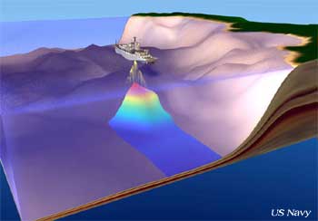
In the last 30 years, modern technologies have been used to map the
topography of the sea floor, revealing a profile of the sea floor that
is anything but flat and lifeless. The sea bed has been found to be
riddled with massive geologic formations that mimic those we have on
land, but on a much, much grander scale. Some of the most notable discoveries
have been deep ocean canyons, which rival the Grand Canyon, seemingly
endless underwater mountain chains that run thousands of miles; deep
trenches, sea mounts, and coral
reefs and atolls formed not by the geologic
processes of earth, but by the diligence of tiny organisms over
thousands of years.
Continental Shelf
– Along the shores of most of the major continents around the
globe, the sea floor slopes gently downward so gradually that a wide
shelf forms just offshore. The width of these relatively shallow shelves
varies from just a few miles to several hundred miles from shore. At
the outermost edges of these shelves the sea floor slopes abruptly and
steeply to the abyssal plain. Scientists believe that the continental
shelves mark the true outline of the land forms that are our continents
and were exposed as shorelines in the geologic past when sea levels
were much lower than today.
Submarine Canyons
- In many continental shelves submarine canyons have been found carving
deep fissures that stretch from near shore out to the deep sea edge
of the shelf. There are a number of theories as to what carved these
giant cracks into the shelves, but the most prominent one states that
sediment transport carved these canyons. Sediment transport in the sea
occurs primarily as underwater landslides of enormous masses of rock
and sediment, usually triggered by turbulent waters during a storm,
or ground movement from an earthquake. The depth at which the submarine
canyons have been cut depends on the make up of the underlying rock
– how susceptible it is to being carved – and how much,
how often and how heavy the materials are that are transported downslope
during an underwater landslide. It is also believed that some canyons
were carved above ground, at a time when sea level was a mile or more
lower than it is today. Those canyons that are now submerged may have
once held rivers and waterfalls that carved the canyon walls, carrying
the sediment and debris down into shallower sea.
The largest and deepest submarine
canyon ever discovered is off the west coast of the Australia, carving
the continental shelf 25 miles out from the coastline to a depth of
over 6,000 feet. Its reach spans over twenty miles wide and its habitat
supports one of the richest underwater ecosystems in the world. Deep,
cold, oxygen-rich waters well up from the deeps into the canyon, providing
sustenance to an enormous array and variety of life forms.
Abyssal Plain – The vast majority of the real
estate at the bottom of the sea is a relatively flat expanse of level
floor. Called the abyssal plains, these average over two miles deep
and may account for as much 79% of the sea floor worldwide. The top
layer of sediment found on the surface of the abyssal plains is rich
in organic matter that has drifted down from above and contains the
remains of virtually everything that lives in the upper reaches to the
midwater ranges of the ocean. For everything that lives, must also die.
All creatures that spend their lives at sea are also buried at sea,
their remains being eaten by other organisms, or left to sink downward
to the abyss. This organically rich and nutritious muck supports untold
numbers of species whose diet thrives on the crumbs and the leftovers
that have settled into the mud of the seabed.
Sea Mounts –
Seamounts are isolated submarine elevations, or underwater mountains.
They are at least 700 meters in height and were created by volcanic
activity. They are mountains, just like we see on land, but the tops
of them don’t break the surface of the ocean. Many of the sea
mounts throughout the world have their peaks far below the ocean surface,
often over a mile down. For many years, people thought that the bottom
of the sea was a flat plain. Imagine the surprise when surveyors discovered
there were entire mountains under the sea! Some of the sea mounts were
found to rise up over a mile from the ocean floor. There is a newly
formed, recently discovered sea mount south of the big island of Hawaii
where a new volcano is building up from the ocean floor. Named Loihi,
the sea mount will one day become a new island, part of the Hawaiian
Island chain, when it breaks the surface of the sea. Right now, the
summit of Loihi is 3,178 feet below sea level. Scientists expect it
will take approximately 10,000 to 40,000 years for Loihi to lose the
title of “sea mount” and become an island.
Under sea mountains don’t always
occur singly, in isolation. Entire mountain ranges have been discovered
on the sea floor. Equipped with the latest in sonar equipment for taking
soundings of the sea floor, oceanographers in the 1950s conducted the
most thorough investigation of the ocean floor to date. The sonar maps
they generated, which profiled the sea bed, showed incredibly high mountains,
in long chains, some of them extending unbroken for thousands of miles.
In the years since the first discovery of undersea mounts, the Mid-Atlantic
Ridge has been measured and mapped to reveal an underwater mountain
range that is over 46,000 miles long, winding from the Arctic Ocean,
around Africa, Asia and Australia, to North America. Compare that to
the longest mountain range on land – the Andes Mountains in South
America are only 4,700 miles long. The Mid-Atlantic Ridge is almost
10 times longer than the Andes!
Volcanic Islands
– Another type of mountain in the sea is an island. It rises from
the sea floor, but reaches above the ocean’s surface, sometimes
just barely. An island is a solitary mountain formed by volcanic activity.
Lava erupting from the sea floor builds up on the sea bed over thousands,
or even millions of years. The lava cools rapidly as it reaches the
ocean water and forms solid rock. Each eruption of the sea floor volcano
builds up the volcano a little bit higher. Until one day, the eruptions
have built the top of the undersea mountain so
high, that it rises above the ocean’s surface.
Sometimes, volcanoes occur in close
proximity to each other on the sea floor, creating a very large island.
For example, the big island of Hawaii is actually five, side-by-side
volcanoes that have grown together. The island chain of countries that
make up Southeast Asia; Indonesia and Papua New Guinea, the Philippine
Islands were all created by volcanic activity on the sea floor. New
Zealand, the Island country off the Southeast coast of Australia, was
also formed by ancient volcanoes.
A volcanic island in the South Pacific
Ocean is also the biggest mountain in the world. Mauna
Loa, one of the volcanic islands that make up the big island of
Hawaii, is the most massive single mountain in the world because of
its sheer bulk. Only about 13,448 feet of Mauna Loa are above sea level,
so it may not seem like a very tall mountain. But, when you start measuring
Mauna Loa from its true base on the bottom of the ocean, in the Hawaiian
Trough, the total height exceeds that of Everest by over 3/4 of a mile.
Mauna Loa is Hawaiian for "Long Mountain", probably because
of its long, gently sloping shape. Mauna Kea, a neighbor of Mauna Loa
on the same island of Hawaii, is actually the tallest mountain in the
world. Mauna Kea is about 350 feet taller than Mauna Loa, but its mass
doesn't compare to that of Mauna Loa. Mauna Loa takes up a lot of space
because it's mass is 9,700 cubic miles of mountain!
Coral Reefs – Another fascinating feature of
the ocean that is part of the topography are coral reefs. Coral reefs
are found in the sea around at the equator all around the world, but
they are not formed by geologic processes. Reefs are hard-as-stone structures
that have been built up over many thousands of years by the activities
of tiny organisms called corals. Corals are related to jellyfish, in
that they are gelatinous creatures, which come from the same family
tree. They begin life as tiny, microscopic polyps that swim about and
float freely in the seas, but eventually take root on the structure
of a reef and spend the rest of their lives living under the protection
of the reef. Their tiny bodies extract minerals from the sea water and
use them to form a hard shell around their bodies. The coral now has
a safe haven from all the creatures in the sea that might like to eat
it. After the coral dies, its protective shell remains behind, adding
just a tiny bit of new “masonry” to the existing reef. This
process is called accretion and, as you can imagine, is a very slow
process. Over many thousands of years, the accumulation of these tiny
bits of reef can build a very substantial structure.
Coral reefs are usually found in warmer,
tropical seas surrounding the equatorial belt. Typically, corals will
invade the seas around a sheltered volcanic island, taking root on the
fresh rock below the surface. The Great Barrier Reef, off the south
coast of Australia, is the largest coral reef in the world. It stretches
for 1,260 miles and covers over 80,000 square miles of ocean floor.
It is estimated that over 350 different species of coral live on the
Barrier Reef and that it took over 600 million years to build the reef
to its current size.
Deep Ocean Trenches
– These are rare occurrences on the sea floor, accounting for
less than 2% of the topography of the sea bed. Trenches occur when heavier
tectonic plates of oceanic crust are subducting under lighter
tectonic plates of continental crust, dragging the leading edge
of the continental crust downward. The pocket of exceptionally deep
space where the two plates are grinding past each other forms a trench
that runs along the margin where the subduction
is happening.
Examples of some deep ocean trenches
that are subduction zones are off the West coast of South America, in
the Peruvian Trench. The Aleutian Trench, in the North Pacific Ocean,
and the deepest, most famous one in the world, the Marianas
Trench, off the coast of the Marianas Islands in the Southeast Pacific.
These are all places where oceanic plates are subducting beneath continental
plates.
Read about
Deep Sea Hydrothermal Vents...